Select a site alphabetically from the choices shown in the box below. Alternatively, browse sculptural examples using the Forward/Back buttons.
Chapters for this volume, along with copies of original in-text images, are available here.


Object type: Part of grave-cover
Measurements:
No direct measurements of Coates 1 were taken when the stone was available for examination, except for its thickness, at 5.5 in. However, the group of grave-covers to which it belongs (see below) has a very standard form and decorative layout, extending to a close standardization of overall width and size of decorative module (Everson and Stocker 1999, 51–7, fig. 14), so that a closely calculated estimate of the dimensions of Coates 1 is possible, as follows:
L. 48.75 cm (19.2 in); W. 32.5 cm (12.8 in); D. 14 cm (5.5 in)
Stone type: [Lincolnshire Limestone, presumed to be of Lincoln origin]
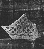
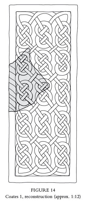
Plate numbers in printed volume: Ill. 8; Figs. 10, 14
Corpus volume reference: Vol 12 p. 96-9
(There may be more views or larger images available for this item. Click on the thumbnail image to view.)
Described in 1904 as found, along with Coates 2, 'a few years ago ...among some farm buildings' at Coates (Mason 1904, 63). One was used as a coping stone for a wall (perhaps Coates 2, which is much the more regularly shaped for reuse), the other as a flagstone of the causeway in the farmyard (Coates 1). The awkward shape and contemporary description of Coates 1 as 'more irregular at the back, having suffered more in the process of breaking up' corresponds with this suggested identification. The discovery was in or before 1895, since that is the date of a letter commenting on the stones from the Rt. Rev. G. F. Browne, then bishop of Stepney, quoted by W. H. Mason and preserved among Mason's archived papers (Nottinghamshire Archives, Acc 6426 box 1 of 5 (uncalendared); the original letter is dated 13 July 1895). Ordnance Survey records suggesting 'c. 1895' as the date of discovery seems to be a rationalization of this same evidence (NMR Number SK 88 SW 13, now NMR Complete Monument Record UID 324962).
The primary published record of the discovery was by Mr W. H. Mason of Morton Hall near Retford (Mason 1904). Mason was a large landowner, prominent public figure and local benefactor in and around Retford and north Nottinghamshire, and at the same time a gentleman antiquary with a special interest in Roman coins and other portable antiquities (Nottinghamshire Archives, DD 716/36/47–85; Mason 1915). The family estate included grazing land at Coates as part of a major land-holding in North Leverton (Throsby 1972, iii, 291; Nottinghamshire Archives, DD 716/15–18) and this was probably the connexion that put this sculpture in his way. Du Boulay Hill's influential survey of early monuments in the county in 1916 reported that the two stones — presumed by him to be from the same monument — were in the possession of Mr Mason 'of Retford' (Hill 1916a, 199); but all details given there are clearly derivative from Mason's published note and there is no indication that Hill actually saw the pieces or is an independent witness as to their latter-day location.
Mason died in 1936. His descendants believed that his antiquarian collection was disbursed appropriately to museums, but without record within the family (in correspondence). Retford Museum certainly received Roman coins, but has no record of these early stones. Renewed efforts to trace their whereabouts were made by Ordnance Survey field staff in the late 1960s or early 1970s, without avail. A fresh effort — including local and family enquiries, consultation of Retford Museum, and a search of the grounds and surviving outbuildings at Morton Hall —undertaken in 2006 for the Corpus project similarly drew a blank. Wood's notice that 'portions of crosses ...survive' at Coates does not, of course, imply that he had seen them in the 1940s, and has no evidential value in this matter (Wood, A. 1947, 18).
A substantial fragment from the middle of a flat, untapered grave-cover of 'Lindsey type' (see below), decorated in low relief and only on its upper surface. The suggestion of Mr W. Stevenson of Alfreton, reported by both Stapleton (1912, 8) and Hill (1916a,199) and represented among Mason's papers by several assertive letters from Stevenson (Nottinghamshire Archives, Acc 6426 box 1 of 5 uncalendared), letters dated 1912 and 1915; this is the elder Mr Stevenson, see Chapter 1, p. 4), that both stones from Coates derived from splitting a large cross-shaft along bedding lines, was claimed to have been checked by Stapleton 'by personal inspection of the relics'. Though such splitting clearly was engineered to create the two twelfth-century fragments at Minting, Lincolnshire (Everson and Stocker 1999, 327–8), at Coates it is clearly a prejudiced and erroneous assertion. Nevertheless, it perhaps underscores the common stone type of Coates 1 and 2.
A (top): The one surviving border is defined by a single cable moulding, and the central panel is occupied by parts of two surviving interconnecting lines of simple pattern F interlace (Cramp 1991, xli, fig. 23), which produce a repetitive figure-of-eight pattern of which only two rows can be seen. The complete figure-of-eight unit measures approximately 18 by 12.5 cm (7 x 4.9 in): the layout and spacing of the lines and rows, insofar as may be judged, is competently regular. Though worn, the decoration stands sharply as a squared U-section against the flat cut-away background in a manner typical of the cover type.
B (long): Undecorated, and evidently of square section since the stone stands flat on this narrow edge in the published photograph (Mason 1904; see Ill. 8).
C (end), D (long) and E (end): Broken
F (bottom): Roughly dressed originally and damaged in reuse
This is an example of a so-called 'Lindsey cover' of the type characterized in the Lincolnshire volume of the Corpus (Everson and Stocker 1999, 51–7). It belongs to the sub-group (b), distinguished by its single cable border (ibid., table 6, fig. 14; see this volume, pp. 61–6, Fig. 10). Because of the parallels now gathered and their uniformity, we may be confident that its decoration originally consisted of three lines of interlace, giving the cover a calculated width of about 54.5 cm (21.5 in), and probably five rows of interlace, giving an overall length — like Cammeringham 1 — of about 135–140 cm (53–55 in), presuming no other decorative element (Fig. 14).
Perhaps the most problematic aspect of both Coates 1 and Coates 2 is the location of their discovery. As published in 1999, the distribution of Lindsey covers of all varieties was confined entirely and remarkably to Lindsey and Lincoln (Everson and Stocker 1999, fig. 15). Since then, two further examples have been identified outside those confines, at the major East Anglian trading centres of Thetford and Norwich in Norfolk (see Figs. 10 and 11), and an argument has been advanced that these represent resident alien merchants, originating from Lincoln and marking that affiliation in their burials by funerary monuments that were distinctively and emblematically identifiable as signaling those origins in the Anglo-Scandinavian trading community of Lincoln (Everson and Stocker 2015). A characteristic feature of the churchyards and churches where these remote finds occur is that they produce exceptional numbers of stone funerary monuments and that they are located immediately adjacent to Anglo-Scandinavian trading hards or beaching places, with their attendant markets (as discussed in Stocker 2000). Coates lies outside Lindsey — albeit marginally — and on the Trent; but it was not that sort of place. It was a minor medieval settlement in the grazing lands at the east end of the run of long east–west parishes whose main settlement focus was two miles and more to the west, at North and South Leverton (Everson and Stocker 2007, especially fig. 5). Its origins as a settlement lay in the seasonal exploitation of grazing and riverside carrs. The riverside trading hards were nearby but on the opposite, Lindsey bank of the river at Marton and around Torksey Island, where boats could get completely out of the main river channel (Stocker and Everson 2006, 215–21). Although the rather larger settlement of Cottam in a similar location to the south did sustain a medieval church with burial rights, there is to date no evidence that Coates ever had a medieval church or chapel. [1] The only hint is the wording 'Cotes Chap.' for this settlement on Thomas Kitchin's county map of c. 1764 (Kitchin 1764), and this might refer to a postmedieval, nonconformist establishment.
Furthermore, the discovery context of the Coates stones was wholly secular and lay in the pragmatic reuse of loads of stone rubble. Mason's original account presumes not only that the stone was brought to Coates for modern building purposes, but that it might probably have come across the river from Lincolnshire (1904, 63). In that context, it is not the discovery date of the stones that is relevant, but rather the construction date of the brick farmhouse of Coates Farm and its outbuildings. One of the surviving outbuildings has the date '1814' picked out in black header-bricks in its gable, and the dentillated cornice and chimney decoration of the farmhouse itself sits comfortably with that early nineteenth-century date. This was also an era of agricultural investment following enclosure in both North and South Leverton parishes, including adjacent Cottam (Tate and Turner 1978, 207).
If not from Coates itself, two candidate sources for this stone suggest themselves, because they offer very local circumstances which might have freed old ecclesiastical masonry for recycling at an appropriate juncture. The emparked church at Gate Burton, just to the east of the long-established crossing at Littleborough, was completely rebuilt in 1866 to designs by G. G. Scott; but there was an earlier rebuilding of Gate Burton St Helen in the 1780s, and it may be significant in indicating a local cross-Trent connexion that the Hutton family who created the eighteenth-century country house and park here were formerly of Treswell, Nottinghamshire (Pevsner et al. 1989, 303; Everson et al. 1991, 96–7).
The more interesting option is that the stones came from Torksey, and this possibility has considerable circumstantial support. Medieval documentation about the ancient Trent ferry at Torksey demonstrates that a group of places on the Nottinghamshire bank (Rampton, Treswell, North and South Leverton, Cottam and Coates) had customary rights in its use. When the river was in flood, the ferry sometimes even landed at Coates (Cole 1905–6, 475–6). A similar cross-Trent link is evidenced by the holdings of the priory of St Leonard at Torksey, which, as granted to Philip Hoby in 1539, occurred in a cluster on the immediate western side of the river (ibid., 517). The major rebuilding of Torksey St Peter church in 1821–2, extending to nave, north aisle and chancel, perhaps occurred too late for the recycling of the Coates stones (Pevsner et al. 1989, 768). But there were two other medieval parish churches in Torksey, one of which — St Mary — lay within the settlement and only a little north of St Peter. The other — All Saints — lay to the south. It was lost in the sixteenth century if not earlier, but its site might easily have been disturbed at a relevant date as the settlement plan of Torksey was re-cast and the secular redevelopment took place to create the modern form of the settlement. [2] For example, Castle View Farm, located in the angle of the modern through road and Sand Lane (SK 73607849), is of the right era in its construction.
If they indeed came from Torksey, the pair of covers from Coates do not in themselves constitute the sort of exceptional concentration of Anglo- Scandinavian funerary sculpture that we have argued was characteristic of trading places of that era, as at St Mark's in Lincoln's Wigford (Everson and Stocker 1999, 76–7, 198–210). As fortuitous off-site survivals, however, they may signal that there had once been such a concentration at Torksey, as one might expect from its particular status as Lincoln's trading suburbium on the Trent/Humber waterway network (Hill, F. 1965, 186, 306–13; Sawyer 1998, 196–7).
[1] We are grateful to Dr Christopher Brooke for information from his valuable ongoing research into Nottinghamshire's 'lost' churches and chapels.
[2] Unpublished 'Notes' on West Lindsey parishes and settlements produced in support of Everson et al. 1991, deposited in the Lincolnshire HER.
