Select a site alphabetically from the choices shown in the box below. Alternatively, browse sculptural examples using the Forward/Back buttons.
Chapters for this volume, along with copies of original in-text images, are available here.


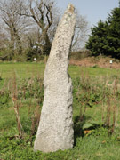
Object type: Pillar-stone
Measurements: H. 220 cm (86.5 in); W. 53 > 40 cm (21 > 16 in); D. 38 > 18 cm (15 > 7 in)
Stone type: Coarse-grained megacrystic granite. The feldspar megacrysts which are up to 25 x 10 mm form about 65% of the rock. The quartz crystals reach 8 mm and form about 35% of the rock. Tourmaline occurs as intergrowths and as discrete crystals up to 7 mm long. A few lakes of white mica up to 8 mm occur. Carnmenellis Granite
Plate numbers in printed volume: Ills. 263-6; Colour Pl. 10
Corpus volume reference: Vol 11 p. 218
(There may be more views or larger images available for this item. Click on the thumbnail image to view.)
Rectangular granite pillar, strongly tapering to a curiously bent and pointed top when seen from the side. From the front it appears rectangular but with a small section lost at the top. The highly laminated granite has broken off in large pieces from both front and back giving the stone this distinctive shape and a generally unworked appearance, so that only a very small portion of what may have been an original face survives on the front, at the top. This section appears undecorated.
Appendix A item (stones of uncertain date)
Although the stone has the appearance of a prehistoric standing stone, charcoal obtained from the stone's socket when it was re-erected in 2005 produced a radio-carbon determination indicating a Roman or possibly early post-Roman date (Hartgroves, Jones, Kirkham et al. 2006, 100–1). Such a date suggests that, although the stone could be of prehistoric origin, it may have been re-used as an early medieval inscribed stone or uninscribed pillar-stone. No inscription is now visible, but the stone is so badly damaged that an inscription could easily have been lost.
The date at which the stone acquired its present shape, either through deliberate damage or natural weathering, is not known.
The function of the stone is uncertain. No evidence for burial or other activity contemporary with the stone was found when it was re-erected. Hartgroves, Jones, Kirkham et al. (2006, 101–2) suggest that it could have been a boundary marker, located on the margin of anciently enclosed land, with open rough ground just to the north. Alternatively, or as well as this, it may have been, as it is now, near the road linking two church sites of early medieval origin at Mabe and Constantine, and close to the boundary between their two parishes.
