Select a site alphabetically from the choices shown in the box below. Alternatively, browse sculptural examples using the Forward/Back buttons.
Chapters for this volume, along with copies of original in-text images, are available here.


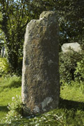
Object type: Pillar-stone
Measurements: H. 185 cm (73 in); W. 66 > 58 cm (26 > 23 in); D. 46 > 34 cm (18 > 13.5 in)
Stone type: Coarse-grained granite. The quartz crystals, which are up to 8 mm across form about 70% of the rock. The feldspars are mostly up to 12 x 2 mm across (a few are up to 20 x 4 mm). A few scattered mica flakes up to 2 mm across occur. Carnmenellis Granite
Plate numbers in printed volume: Ills. 260-2; Colour Pl. 9
Corpus volume reference: Vol 11 p. 217
(There may be more views or larger images available for this item. Click on the thumbnail image to view.)
Rectangular section granite pillar, with broken or deliberately cut top resulting in a flat-topped finger-like protrusion 15 cm (6 in) high, in the top of which is an iron fixing. All faces have been dressed smooth, although the front (south-west facing side) has a flake of granite missing down one side.
A (south-west): Within the 'finger' at the top of the pillar is a shallowly-cut incised cross with expanded terminal at the top only, 15 cm (6 in) high and 10 cm (4 in) across.
B (south-east): Undecorated
C (north-east): Near the top of the pillar, just below the broken section, is a shallowly cut incised latin cross, 13 cm (5 in) high and 10 cm (4 in) across.
D (north-west): Undecorated. The stone is heavily dissected with vertical and horizontal lines forming a rectangular pattern, which are probably the result of natural erosion along joint-lines in the granite (Thomas, A. C. 1994, 11–12). These give the appearance of decoration and/or inscriptions and have been mistaken as such in the past (Ordnance Survey Archaeological Index Card SW73SE9). Some of the horizontal lines, extending on to the eastern edge of the stone, slightly resemble ogam.
Appendix A item (stones of uncertain date)
The stone has the appearance of a pre-historic standing stone, modified at the top for some purpose and with the addition at some date of the incised crosses. The Ordnance Survey's archaeological surveyor in 1968 suggested that the modification could have been to allow it to support the lantern, shown by Henderson (Ordnance Survey Archaeological Index Card SW73SE9; Henderson, C. ?1932, 15–16, pl. IVa). Although the markings on the north-west face have been interpreted as the remains of an inscription or ornament, Thomas takes them as natural markings (Thomas, A. C. 1994, 12) and that opinion is supported here. However, a recent radio-carbon determination from charcoal from the socket of a standing stone at nearby Eathorne (Mabe 2 below), which produced a Roman to early medieval period date (Hartgroves, Jones, Kirkham et al. 2006, 101–2), points to the possibility that this stone might likewise be of post-Roman (early medieval) date and an original feature of the site. The period at which the incised crosses were added is unknown: Thomas (who noted only one) has suggested a medieval date (Thomas, A. C. 1994, 11–12; Thomas, A. C. 2007, 124–5, fig. 3), but it is impossible to be sure.
If of early medieval origin, the stone would be an example of an uninscribed pillar-stone.
The place-name of Mabe, Lavabe in 1549, contains the element *lann and a personal name; the element *lann indicates a church-site of early medieval origin (Padel 1988, 113). For much of the later medieval period Mabe was a chapelry, subservient to Mylor (Henderson, C. ?1932, 3–6).
