Select a site alphabetically from the choices shown in the box below. Alternatively, browse sculptural examples using the Forward/Back buttons.
Chapters for this volume, along with copies of original in-text images, are available here.


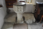
Object type: Part of cross-base
Measurements: L. 191 cm (75 in); W. 90 cm (35.5 in); H./D. 26 cm (10 in); Mortice 53 cm x 33 cm (21.75 x 13 in)
Stone type: Coarse-grained, abundantly megacrystic granite. Common, small, feldspar megacrysts up to 15 mm x 3 mm form about 70% of the rock; quartz crystals up to 6 mm across form about 30%. A few flakes of white mica occur. Carnmenellis Granite
Plate numbers in printed volume: Ill. 256
Corpus volume reference: Vol 11 p. 215
(There may be more views or larger images available for this item. Click on the thumbnail image to view.)
Broken section of an undecorated rectangular cross-base. The smooth-sided rectangular mortice is cut completely through the stone. Although the stone is broken, a slight return on the broken side shows that the mortice is nearly complete. On the upper surface on each of the short sides of the mortice a slight recess may show where the cross was seated.
Appendix A item (stones of uncertain date)
Although the cross is now missing, the very large size of the base, possibly as much as 1.9 x 1.2 metres across originally, suggests a substantial monument which is likely to have been of early medieval origin (see Chapter VI above, p. 63). This is in part corroborated by legends relating to the destruction of the monument, which may imply that the cross-head was circular with four holes (Davey 2006, 40). The fact that the cross is marked on Gascoyne's 1699 map of Cornwall indicates that it was a significant landscape feature right up to the end of the seventeenth century.
In its original location, the cross stood on Kea Cross Common (Davey 2006, 39), at a junction where roads diverged, one leading to the farms of Higher Trelease and Halwyn, the other to site of the former parish church, now known as Old Kea. The names of Trelease and Halwyn, meaning the 'farming estate by the court' and the 'white hall' (Padel 1985, 230–1, 128, 120–1) may potentially indicate an early medieval high status site in the area, while Old Kea is the site of a land-owning religious community recorded in the Geld Inquest associated with the Exeter version of Domesday Book but of which there is no later trace (Olson 1989, 90, 105; Orme 2010, 130–1).
Landighe, the *lann of Ke, which is the original name of the church site, indicates its early medieval origin (Padel 1988, 130); by 1086 it was a manor held by Godwin from the Count of Mortain (Thorn and Thorn 1979, 5,24,12). In its original location, the cross may have been marking the way to the church, a boundary of ecclesiastical land, or both.
